Maya Geography
Essential Themes
Geography: Why do people live and build where they do?
Review: What is geography?
Geography: Why do people live and build where they do?
Review: What is geography?

A long, long time ago, about 2500 BCE, an ancient tribe of Central American Indians called the Olmecs settled in the rainforests of the Yucatan Peninsula of Central America. About two thousand years later, around 400 BCE, a new people suddenly appeared. Despite the time difference, there is probably a link between the Olmecs and the Maya. From around 400 BCE until 900 CE, the Maya were the civilization in Mesoamerica.
Throughout Central America, the Maya built hundreds of religious centers and cities, each filled with huge pyramids and temples, and always at least one ball court. The roads that they built to link these centers of religion and learning ran for miles through the jungles and swamps that surrounded them. The Maya studied art, architecture, medicine, drama, music, dance, and magic. They even believed that mirrors were portals, a way to communicate with their gods.
Today, you will begin your study of the Maya, a people who built a civilization that lasted 1500 years. As always, you will begin your study with geography. Remember that geography is the study of how people interact with their environment. The place a people settle can influence - even determine - everything from the type of government they have and their religious practices to the types of jobs they work at and the kind of clothing they wear. The places the Maya settled posed challenges, as you will see. The challenges, however, did not stop the Maya people from building the longest lasting, most dominant civilization in the Americas.
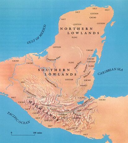
Where is the Yucatan Peninsula?
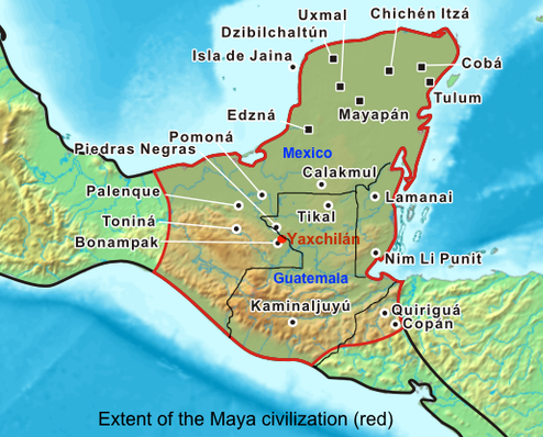
The Maya civilization stretched from southern Mexico in the north - an area referred to as the lowlands that included a hot coastal plain along the Pacific Ocean and a tropical rainforest in the Yucatan Peninsula - to the highlands of modern-day Guatemala, Belize, El Salvador, and Honduras. The lowlands in the north produced crops. The main crop for the Maya was maize, or corn. However, Maya farmers also grew squash, beans, chili peppers, cacao, cotton for the weaving of light cloth, and sisal for the manufacture of heavy cloth and rope. The northern lowland climate is hot, and infrequent rainfall means that there are few permanent rivers or lakes. Large sinkholes filled with rainwater provided precious water for settlers in that part of the lowlands.
The southern lowlands were starkly different from the northern lowlands. The southern lowlands include tropical rainforest. Notably, this area included the Yucatan peninsula of southeastern Mexico. The Yucatan Peninsula separates the Gulf of Mexico from the Caribbean Sea. This area gets as much as 160 inches of rainfall annually. Additionally, it is fed by the mighty Usumacinta River. The result is a series of rivers that were vital to the Maya for the transportation of both people and trade goods.
|
The highlands to the south are a wide section of valleys and volcanic mountains that are a part of the Sierra Madre range. A narrow coastal plain along the Pacific Ocean forms it southern boundary. Although the area is subject to tsunamis, volcanoes and earthquakes, the soil here is fertile and the climate is pleasantly cooler than the lowlands to the north.
|
|
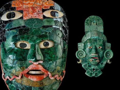
The mountains of the volcanic Highlands were the source of obsidian, jade and cinnabar (shown in the masks below), hematite and other precious metals and minerals. Because many of these items were mined in caves high in the mountains and because caves had a sacred place in Maya mythology, stones such as obsidian and jade took on sacred significance. These minerals also formed the foundation of Maya trade. Although the lowlands were not the source of any of these trade goods, the lowlands still played an important trade role as the origin of the transportation routes
Many dangerous animals occupied the forested region of the peninsula. They included jaguars, caiman (a small but fierce type of crocodile), the bull shark, and many species of poisonous snakes. The Maya tried their best to avoid those animals while they hunted the forest for foods that included deer, turkey, peccaries and tapirs (both members of the pig family), rabbits, and large rodents such as the peca and the agouti. Many varieties of monkeys and beautifully plumed quetzal (a type of bird) occupied the upper canopy of the rainforest.
We call the peoples who inhabited the broad, diverse stretch of land described above the Maya. Their name comes from the ancient Yucatan city of Mayapan, the last capital of one of the Maya kingdoms.
BRAINBOX: Why do you think archaeologists might have a hard time finding the ruins of Maya cities?
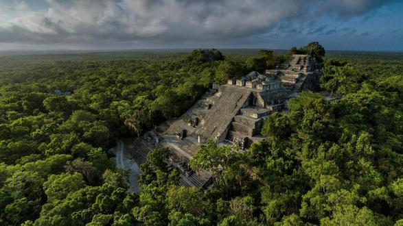
Many of the Maya centers of religion and learning - their cities - were built in the rainforest, on the Yucatan Peninsula. Because of that, many Maya sites remained a mystery for hundreds of years. The rainforest is a dense tangle of trees and vines. Historically, archaeologists could not use airplanes or helicopters to track down cities hidden in the rainforest. They had to travel on foot. Additionally, all archaeological work stopped from September to May because of the rain. During those months, it is just too wet to conduct an archaeological dig. Traditionally, dig teams worked from May to August, but those months are among the hottest on the calendar. In spite of those difficulties, some archaeologists have been willing to brave the dangers of the rainforest to learn more about the mysterious Maya. With the use of new technologies, scientists have been able to advance their studies and are continually discovering more fascinating details about the size and strength of the mighty Maya civilization.
Brainbox: Why do you think the Maya built their cities in the rainforest?
The rainforest - home to many Maya cities - made crossing land difficult. Geographic features that make travel difficult are called natural barriers. The land of the Maya had many natural barriers. In addition to the rainforest, the Maya - and any potential invaders - had to contend with many large bodies of water. In fact, because most of the ancient Maya civilization was on a peninsula, it was surrounded on three sides by water. On the left side of the peninsula is the Gulf of Mexico. On the right side is the Caribbean Sea and the Gulf of Honduras. To the south is the Pacific Ocean. Those bodies of water made it easy for the Maya to see the approach of invaders and also made it easier to defend the land. In part, because of its geography, the Maya civilization was able to survive for 1500 years.
The rainforest - home to many Maya cities - made crossing land difficult. Geographic features that make travel difficult are called natural barriers. The land of the Maya had many natural barriers. In addition to the rainforest, the Maya - and any potential invaders - had to contend with many large bodies of water. In fact, because most of the ancient Maya civilization was on a peninsula, it was surrounded on three sides by water. On the left side of the peninsula is the Gulf of Mexico. On the right side is the Caribbean Sea and the Gulf of Honduras. To the south is the Pacific Ocean. Those bodies of water made it easy for the Maya to see the approach of invaders and also made it easier to defend the land. In part, because of its geography, the Maya civilization was able to survive for 1500 years.


